| Tromelin Island Île Tromelin | ||||
|---|---|---|---|---|
| ||||
| Motto: Liberté, égalité, fraternité | ||||
| Anthem: La Marseillaise | ||||
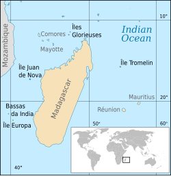
| Location of the Scattered islands in the Indian Ocean: • 1 : Bassas da India • 2 : Europa Island • 3 : Glorioso Islands • 4 : Juan de Nova Island • 5 : Tromelin Island (KM : Comoros, MG: Madagascar, MU: Mauritius, MZ: Mozambique, RE: Réunion, YT: Mayotte) | ||||
Tromelin Island (![]() /ˌtroʊmlɪn ˈaɪlənd/; French: Île Tromelin, pronounced: [il tʁɔmlɛ̃]) is a low, flat 0.8-square-kilometre (200-acre) island in the Indian Ocean, about 350 kilometres (220 mi) east of Madagascar (geographic coordinates: 15°53′32″S 54°31′29″E / 15.89222°S 54.52472°E). There are no harbours or anchorages and access by sea is difficult. The island has a 1,200-metre (3,900 ft) airstrip. It is a French territory. It is claimed by Mauritius and Seychelles.
/ˌtroʊmlɪn ˈaɪlənd/; French: Île Tromelin, pronounced: [il tʁɔmlɛ̃]) is a low, flat 0.8-square-kilometre (200-acre) island in the Indian Ocean, about 350 kilometres (220 mi) east of Madagascar (geographic coordinates: 15°53′32″S 54°31′29″E / 15.89222°S 54.52472°E). There are no harbours or anchorages and access by sea is difficult. The island has a 1,200-metre (3,900 ft) airstrip. It is a French territory. It is claimed by Mauritius and Seychelles.
Tromelin is a low, scrub-covered sandbank about 1,700 metres (1.1 mi) long and 700 metres (0.43 mi) wide, surrounded by coral reefs. The island is 7 metres (23 ft) high at its highest point. It is a nesting site for seabirds and turtles.
History
The island was first recorded by a French navigator in 1722. In 1761 the French ship Utile, carrying slaves from Madagascar to Mauritius, ran onto the reefs of the island. The crew reached Madagascar in a raft, abandoning some 60 slaves on the desert island. Fifteen years later in 1776, the chevalier de Tromelin (from whom the island takes its name), captain of the French warship La Dauphine, visited the island and rescued the survivors — seven women and an eight-month-old child. Tromelin Island was occupied by France in 1954 while it was part of Mauritius and is claimed by Mauritius.
Tromelin has an Exclusive Economic Zone (EEZ) of 280,000 square kilometres (110,000 sq mi), contiguous with that of Réunion. The island's weather station, which warns of cyclones, is manned by meteorologists from Réunion.
External links-(COPY OF WIKIPEDIA)
| Wikimedia Commons has media related to: Tromelin |


No comments:
Post a Comment