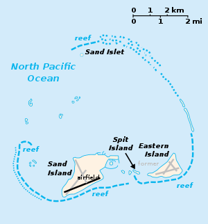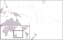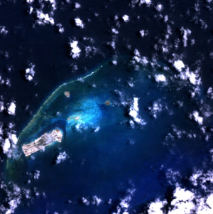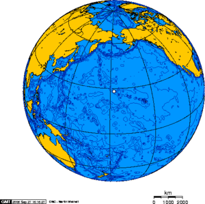
Midway Atoll (![]() /ˈmɪdweɪ/; also called Midway Island and Midway Islands; Hawaiian: Pihemanu Kauihelani) is a 2.4-square-mile (6.2-km²) atoll in the North Pacific Ocean, near the northwestern end of the Hawaiian archipelago, about a third of the way between Honolulu, Hawaii, and Tokyo, Japan. Uniquely among the Hawaiian islands, Midway observes UTC-11 (also known as Samoa Time), eleven hours behind Coordinated Universal Time and one hour behind the state of Hawaiʻi. Midway Atoll is an unorganized, unincorporated territory of the United States, and the former home of the Midway Naval Air Station (former ICAO PMDY). It is less than 140 nautical miles (259 km; 161 mi) east of the International Date Line, about 2,800 nautical miles (5,200 km; 3,200 mi) west of San Francisco, and 2,200 nautical miles (4,100 km; 2,500 mi) east of Tokyo. It consists of a ring-shaped barrier reef and several sand islets. The two significant pieces of land, Sand Island and Eastern Island, are habitat for millions of seabirds. The island sizes are shown here:
/ˈmɪdweɪ/; also called Midway Island and Midway Islands; Hawaiian: Pihemanu Kauihelani) is a 2.4-square-mile (6.2-km²) atoll in the North Pacific Ocean, near the northwestern end of the Hawaiian archipelago, about a third of the way between Honolulu, Hawaii, and Tokyo, Japan. Uniquely among the Hawaiian islands, Midway observes UTC-11 (also known as Samoa Time), eleven hours behind Coordinated Universal Time and one hour behind the state of Hawaiʻi. Midway Atoll is an unorganized, unincorporated territory of the United States, and the former home of the Midway Naval Air Station (former ICAO PMDY). It is less than 140 nautical miles (259 km; 161 mi) east of the International Date Line, about 2,800 nautical miles (5,200 km; 3,200 mi) west of San Francisco, and 2,200 nautical miles (4,100 km; 2,500 mi) east of Tokyo. It consists of a ring-shaped barrier reef and several sand islets. The two significant pieces of land, Sand Island and Eastern Island, are habitat for millions of seabirds. The island sizes are shown here:
Island | acres | hectares |
|---|---|---|
| Sand Island | 1,200 | 486 |
| Eastern Island | 334 | 135 |
| Spit Island | 15 | 6 |
| Midway Atoll | 1,540 | 623 |
| Lagoon | 14,800 | 6,000 |
According to other sources, Sand Island measures 1,250 acres (5.1 km2) in area and the lagoon within the fringing rim of coral reef 9,900 acres (4,000 ha). The atoll, which has a small population (approximately 60 in 2009, but no indigenous inhabitants), is designated an insular area under the authority of the U.S. Department of the Interior. The Midway Atoll National Wildlife Refuge, encompassing 590,991.50 acres (239,165.77 ha)[1] of land and water (mostly water) in the surrounding area, is administered by the U.S. Fish and Wildlife Service (FWS). The visitor program reopened in January 2008 and there are facilities for visitors. Travel to the Atoll is possible through organized tour companies or as a FWS volunteer.[2][3] The tours focus on the ecology of Midway and the military history. The economy is derived solely from governmental sources and tourist fees. All food and manufactured goods are imported. The refuge and most of its surrounding area are part of the larger Papahānaumokuākea Marine National Monument.
Midway, as its name suggests, lies nearly halfway between North America and Asia, and almost halfway around the world from Greenwich, England. For statistical purposes, Midway is grouped as one of the United States Minor Outlying Islands.
Midway was the focus point of the Battle of Midway, one of the most important naval battles of the Pacific Campaign in World War II, fought on June 4–6, 1942. Nearby the islands, the United States Navy defeated a Japanese attack against the Midway Islands, marking a turning-point in the war in the Pacific Theater.
Contents[hide] |
[edit] Geography and geology
Midway Atoll is part of a chain of volcanic islands, atolls, and seamounts extending from Hawai'i up to the tip of the Aleutian Islands and known as the Hawaii-Emperor chain. Midway was formed roughly 28 million years ago when the seabed underneath it was over the same hotspot from which the Island of Hawai'i is now being formed. In fact, Midway was once a shield volcano perhaps as large as the island of Lana'i. As the volcano piled up lava flows building the island, its weight depressed the crust and the island slowly subsided over a period of millions of years, a process known as isostatic adjustment. As the island subsided, a coral reef around the former volcanic island was able to maintain itself near sea level by growing upwards. That reef is now over 516 ft (160 m) thick (Ladd, Tracey, & Gross, 1967; in the lagoon, 1,261 feet (384 m), comprised mostly post-Miocene limestones with a layer of upper Miocene (Tertiary g) sediments and lower Miocene (Tertiary e) limestones at the bottom overlying the basalts. What remains today is a shallow water atoll about 6 miles (10 km) across.
The atoll has some 20 miles (32 km) of roads, 4.8 miles (7.8 km) of pipelines, one port on Sand Island (World Port Index Nr. 56328, MIDWAY ISLAND), and one active runway (rwy 06/24, around 8,000 feet (2,400 m) long). As of 2004, Henderson Field airfield at Midway Atoll has been designated as an emergency diversion airport for aircraft flying under ETOPS rules. Although the FWS closed all airport operations on November 22, 2004, public access to the island was restored beginning March 2008.[4]
Eastern Island Airstrip is a disused airfield in use by U.S. forces during the Battle of Midway, June 4–6, 1942. It is mostly constructed of Perforated Steel Plate sectional matting, built by the U.S. Navy Seabees.
[edit] History
[edit] Nineteenth century
The atoll was sighted on July 5, 1859 by Captain N.C. Middlebrooks, though he was most commonly known as Captain Brooks, of the sealing ship Gambia. The islands were named the "Middlebrook Islands" or the "Brook Islands". Brooks claimed Midway for the United States under the Guano Islands Act of 1856, which authorized Americans to occupy uninhabited islands temporarily to obtain guano. On 28 August 1867, Captain William Reynolds of the USS Lackawanna formally took possession of the atoll for the United States; the name changed to "Midway" some time after this. The atoll became the first Pacific islands annexed by the U.S. government, as the Unincorporated Territory of Midway Island, and administered by the United States Navy. Midway is the only island in the entire Hawaiian archipelago that was not later part of the State of Hawaii.

The first attempt at "settlement" was in 1871, when the Pacific Mail Steamship Company started a project of blasting and dredging a ship channel through the reef to the lagoon using money put up by the United States Congress. The purpose was to establish a mid-ocean coaling station avoiding the high taxes imposed at ports controlled by the Hawaiians. The project was shortly a complete failure, and the USS Saginaw evacuated the last of the channel project's work force in October 1871. It then ran aground at Kure Atoll, stranding everyone on the ship. (All aboard were rescued with the exception of four who drowned in an attempt by five crew members to sail to Hawaii in an open boat to seek help. The party reached Kauai, but the boat was overturned just offshore and only William Halford survived and was able to bring help to the stranded).
[edit] Early twentieth century
In 1903, workers for the Commercial Pacific Cable Company took up residence on the island as part of the effort to lay a trans-Pacific telegraph cable. These workers introduced many non-native species to the island, including the canary, cycad, Norfolk Island pine, she-oak, coconut, and various deciduous trees, along with ants, cockroaches, termites, centipedes, and countless others.
Later that year, President Theodore Roosevelt placed the atoll under the control of the United States Navy, which on 20 January 1903 opened a radio station in response to complaints from cable company workers about Japanese squatters and poachers. Between 1904 to 1908 Roosevelt stationed 21 Marines on the island to end wanton destruction of bird life and keep Midway safe as a U.S. possession, protecting the cable station.
In 1935, operations began for the China Clippers, flying boats operated by Pan American Airlines. The Clippers island-hopped from San Francisco to China, providing the fastest and most luxurious route to the Orient and bringing tourists to Midway until 1941. Only the extremely wealthy could afford a Clipper trip, which in the 1930s cost more than three times the annual salary of an average American. With Midway on the route between Honolulu and Wake Island, the seaplanes landed in the atoll and pulled up to a float offshore in the lagoon. Tourists transferred to a small powerboat that ferried them to a pier, then rode in "woody" wagons to the Pan Am Hotel or the "Gooneyville Lodge", named after the ubiquitous "Gooney birds" (albatrosses).
[edit] World War II
The location of Midway in the Pacific became important to the military. Midway was a convenient refueling stop on transpacific flights, and was also an important stop for Navy ships. Beginning in 1940, as tensions with the Japanese were rising, Midway was deemed second only to Pearl Harbor in importance to protecting the U.S. west coast. Airstrips, gun emplacements and a seaplane base quickly materialized on the tiny atoll. The channel was widened, and Naval Air Station Midway was completed. Architect Albert Kahn designed the Officer's quarters, the mall and several other hangars and buildings. Midway was also an important submarine base. Midway's importance to the U.S. was brought into focus on December 7, 1941 with the Japanese attack on Pearl Harbor. Midway was attacked for the first time on December 7, 1941, and the Japanese force was successfully repulsed in the first American victory of the war. A Japanese submarine bombarded Midway on February 10, 1942.[5] Four months later, on June 4, 1942, a naval battle near Midway resulted in the U.S. Navy exacting a devastating defeat of the Japanese Navy. Four capital Japanese aircraft carriers, namely Akagi, Kaga, Hiryu and Soryu were sunk, along with the loss of hundreds of other Japanese aircraft, losses that the Japanese could not, and would never be able to replace. The US lost the aircraft carrier USS Yorktown (CV-5) in retaliation, along with a number of their carrier and land-based aircraft the Japanese either shot down or bombarded through dive-bombing towards the airfields by aircraft, mostly of Hiryu. The Battle of Midway was, by most accounts, the beginning of the end of the Japanese Navy's control of the Pacific Ocean.
[edit] Korean and Vietnam Wars
| Historical populations | ||
|---|---|---|
| Year | Pop. | %± |
| 1970 | 2,220 | — |
| 1980 | 453 | −79.6% |
| 1990 | 13 | −97.1% |
| 2000 | 4 | −69.2% |
| 2010 | 0 | −100.0% |
From August 1, 1941 to 1945, it was occupied by U.S. military forces. In 1950, the Navy decommissioned Naval Air Station Midway, only to re-commission it again to support the Korean War. Thousands of troops on ships and planes stopped at Midway for refueling and emergency repairs. From 1968 to September 10, 1993, Midway Island was a Navy Air Facility. During the Cold War, the U.S. established an underwater listening post at Midway to track Soviet submarines. The facility remained secret until its demolition at the end of the Cold War. U.S. Navy WV-2 (EC-121K) "Willy Victor" radar planes flew night and day as an extension of the DEW Line (Distant Early Warning Line), and antenna fields covered the islands.
With about 3,500 people living on Sand Island, Midway also supported the U.S. troops during the Vietnam War. In June 1969, President Richard Nixon held a secret meeting with South Vietnamese President Nguyen Van Thieu at the Officer-in-Charge house or "Midway House".
[edit] Civilian jurisdiction
In 1978, the Navy downgraded Midway from a Naval Air Station to a Naval Air Facility and large numbers of personnel and dependents began leaving the island. With the war in Vietnam over, and with the introduction of reconnaissance satellites and nuclear submarines, Midway's significance to U.S.-national security was diminished. The World War II facilities at Sand and Eastern Islands were listed on the National Register of Historic Places on May 28, 1987.
Midway was designated an overlay National Wildlife Refuge on April 22, 1988 while still under the primary jurisdiction of the Navy. As part of the Base Realignment and Closure process, the Navy facility on Midway has been operationally closed since September 10, 1993, although the Navy assumed responsibility for cleaning up environmental contamination at Naval Air Facility Midway Island.
Beginning August 7, 1996, the general public could visit the atoll through study ecotours.[6] This program ended in 2002,[7] but another visitor program was approved and began operating in March 2008.[4][8]
On October 31, 1996, President Bill Clinton signed Executive Order 13022, which transferred the jurisdiction and control of the atoll to the U.S. Department of the Interior. The Fish and Wildlife Service assumed management of the Midway Atoll National Wildlife Refuge. The last contingent of Navy personnel left Midway on June 30, 1997 after an ambitious environmental cleanup program was completed.
On June 15, 2006, President George W. Bush designated the Northwestern Hawaiian Islands as a national monument. The Northwestern Hawaiian Islands Marine National Monument encompasses 105,564 square nautical miles (139,798 sq mi; 362,074 km2), and includes 3,910 square nautical miles (5,178 sq mi; 13,411 km2) of coral reef habitat.[9] The Monument also includes the Hawaiian Islands National Wildlife Refuge, and the Midway Atoll National Wildlife Refuge.
In 2007, the Monument's name was changed to Papahānaumokuākea (pronounced PA-pa-ha-NOW-mo-KOO-ah-KAY-uh) Marine National Monument.[10] The National Monument is managed by the U.S. Fish and Wildlife Service, the National Oceanic and Atmospheric Administration (NOAA), and the State of Hawaii.
[edit] Wildlife
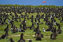
Midway Atoll is now home to 67-70% of the world's Laysan Albatross population, and 34-39% of the global black-footed albatross.[11]
While Midway supports nearly three million birds, each seabird species has carved out a specific site on the atoll in which to nest. Seventeen different species of seabird can be found, the rarest of which is the short-tailed albatross, otherwise known as the “Golden Gooney.” Fewer than 2,200 are believed to exist due to excessive feather hunting in the late nineteenth century.[12]
Over 250 different species of marine life are found in the 300,000 acres (1,200 km2) of lagoon and surrounding waters. The critically endangered Hawaiian Monk Seals raise their pups on the beaches. Monk seals are benthic foragers and rely on the Midway Atoll’s reef fish, squid, octopus and crustaceans. Green sea turtles, another threatened species, occasionally nest on the island. The first was found in 2006 on Spit Island and another in 2007 on Sand Island. A resident pod of 300 spinner dolphins live in the lagoons and nearshore waters.[13]
Ironwood trees from Australia were planted to act as windbreaks. Seventy-five percent of the 200 species of plants on Midway were introduced. The FWS has recently re-introduced the endangered Laysan duck (Midway is part of its assumed pre-historic range) to the Atoll, while at the same time extending efforts to exterminate invasive plant species.
[edit] Environmental issues
The islands of Midway Atoll have been extensively altered as a result of human habitation. Starting in 1869 with a project to blast the reefs and create a port on Sand Island, the ecology of Midway has been changing.
[edit] Marine debris
Midway Atoll, in common with all the Hawaiian Islands, receives substantial amounts of marine debris from the Great Pacific Garbage Patch. Consisting of ninety percent plastic, this debris accumulates on the beaches of Midway. This garbage represents a hazard to the bird population of the island.
Of the 1.5 million Laysan Albatrosses that inhabit Midway, nearly all are found to have plastic in their digestive system.[14] Approximately one-third of the chicks die.[15]
[edit] Lead poisoning
Lead paint on the buildings still poses an environmental hazard (Avian lead poisoning) to the albatross population of the island. The cost of stripping the paint is estimated to be $5 million.[16] It was announced in September 2010, that the Federal Government would plan to carry out the clean up by July 2011.[17]
[edit] 2011 Tsunami
The 2011 Tōhoku earthquake and tsunami caused many deaths among the bird population on Midway.[18] Researchers had ample warning prior to the tsunami. Scientists on the island however do not think it will have long-term negative impacts on the bird populations.
[edit] Transportation
The usual method of reaching Sand Island, Midway Atoll's only populated island, is via Henderson Field Airport. (copy of wikipedia)
