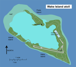
 Map of Wake Island
Geography Location North Pacific Coordinates
 19°18′N 166°38′E / 19.3°N 166.633°E / 19.3; 166.633Coordinates: 19°18′N 166°38′E / 19.3°N 166.633°E / 19.3; 166.633
 Total islands 3 Area 2.85 sq mi (7.38 km
2) Coastline 12.0 mi (19.3 km)
[1] Highest elevation 20 ft (6 m) Highest point Ducks Point Country
Population = 2100
Wake Island ( /ˈweɪk/; also known as Wake Atoll) is a coral atoll having a coastline of 12 miles (19 km) in the North Pacific Ocean, located about two-thirds of the way from Honolulu 2,300 statute miles (3,700 km) west to Guam 1,510 statute miles (2,430 km) east. It is an unorganized, unincorporated territory of the United States, administered by the Office of Insular Affairs, U.S. Department of the Interior. Access to the island is restricted, and all current activities on the island are managed by the United States Air Force. There is also a missile facility operated by the United States Army. The largest island (Wake Island) is the center of activity on the atoll and has a runway of 9,800 feet (3,000 m).
On January 6, 2009, President George W. Bush included the atoll as a part of the Pacific Remote Islands Marine National Monument.[2][3] For statistical purposes, Wake is grouped as one of the United States Minor Outlying Islands.
[edit] Geography

Aerial overview of the atoll
Wake is located to the west of the International Date Line and sits in the Wake Island Time Zone, one day ahead of the 50 U.S. states.
Although Wake is officially called an island in the singular form, it is actually an atoll comprising three islands surrounding a central lagoon:[4]
| Island | acres | hectares |
| Wake Islet | 1,367.04 | 553.22 |
| Wilkes Islet | 197.44 | 79.90 |
| Peale Islet | 256.83 | 103.94 |
| Wake Island | 1,821.31 | 737.06 |
| Lagoon (water) | 1,480 | 600 |
| Sand Flat | 910 | 370 |
Referring to the atoll as an island is the result of a pre-World War II desire by the United States Navy to distinguish Wake from other atolls, most of which were Japanese territory.[citation needed]
[edit] Climate

Wake Island's Main Lagoon
Wake Island lies in the tropical zone but is subject to periodic temperate storms during the winter. Sea surface temperatures are warm all year long, reaching above 80 °F (27 °C) in summer and autumn. Typhoons occasionally pass over the island.
[edit] Typhoons
On September 16, 1967, at 10:40 pm local time, the eye of Typhoon Sarah passed over the island. Sustained winds in the eyewall were 130 knots, from the north before the eye, and from the south afterward. All non-reinforced structures were demolished. There were no serious injuries, and the population was evacuated after the storm.[5]
On August 28, 2006, the United States Air Force evacuated all 188 residents and suspended all operations as category 5 Super Typhoon Ioke headed toward Wake. By August 31, the southwestern eyewall of the storm passed over the island, with winds well over 185 miles per hour (298 km/h),[6] driving a 20 ft (6 m) storm surge and waves directly into the lagoon inflicting major damage.[7] A US Air Force assessment and repair team returned to the island in September 2006 and restored limited function to the airfield and facilities leading ultimately to a full return to normal operations.
[edit] History
[edit] Pre-European discovery
Indigenous Marshallese oral tradition suggests that prior to European exploration, nearby Marshall Islanders traveled to what is now Wake Island, which the travelers called Enen-kio after a small orange shrub-flower said to have been found on the atoll. In the ancient Marshallese religion, rituals surrounding the tattooing of tribal chiefs, called Iroijlaplap, were done using fresh human bones, which required a human sacrifice. A man could save himself from being sacrificed if he obtained a wing bone from a very large seabird said to have existed on Enen-kio. Small groups would brave traveling to the atoll in hopes of obtaining this bone, saving the life of the potential human sacrifice.[8][9] No evidence exists to suggest there was ever a permanent settlement by Marshall Islanders on Wake Island.[8]
Based upon oral tradition,[10] along with concepts of first-usage land rights commonly held in Micronesian cultures as legitimate for settling indigenous land disputes,[11][12][13] a group of Marshall Island descendants formed the Kingdom of EnenKio to claim ownership of Wake Island. The Marshall Islands and U.S. governments, who have competing claims to the island, vigorously deny this.
[edit] European discovery and exploration
On October 20, 1568, Álvaro de Mendaña de Neyra, a Spanish explorer with two ships, Los Reyes and Todos Santos, discovered "a low barren island, judged to be eight leagues in circumference", to which he gave the name of "San Francisco". The island was eventually named for Captain William Wake, master of the British trading schooner, Prince William Henry, who visited in 1796.[14]
Jeremiah N. Reynolds' 1828 report to the US House of Representatives describes Capt. Edward Gardner's discovery of a 25-mile (40 km) long island situated at 19°15' N, 166°32' E, with a reef at the eastern edge when he was captain of the Bellona in 1823. The island was "covered with wood, having a very green and rural appearance" and, Reynolds concluded, was probably Wake Island. It was placed on charts by John Arrowsmith.[15]
On December 20, 1840, the United States Exploring Expedition, commanded by Commodore Charles Wilkes of the U.S. Navy, landed on Wake and surveyed the island. Wilkes described the atoll as "a low coral one, of triangular form and eight feet above the surface. It has a large lagoon in the centre, which was well filled with fish of a variety of species among these were some fine mullet." He also noted that Wake had no fresh water but was covered with shrubs, "the most abundant of which was the tournefortia." The expedition's naturalist, Titian Peale, collected many new specimens, including an egg from a short-tailed albatross and various marine life specimens.
[edit] Wreck of the Libelle
Wake Island first received international attention with the wreck of the barque Libelle. On the night of March 4, 1866, the 650 ton Libelle, of Bremen, Germany, struck the eastern reef of Wake Island during a gale. Commanded by Captain Tobias, the ship was en route from San Francisco to Hong Kong. Among its passengers were opera singer Anna Bishop (ex wife of the celebrated French harpist Nicolas Bochsa), her husband Martin Schultz (a New York diamond merchant), and three other members of an English opera troupe.
After 21 days on Wake, the 30 stranded passengers and crewmen sailed in a longboat and the gig for the then Spanish island of Guam. The longboat, containing the opera troupe, Mr. Schultz and other passengers, reached Guam April on 8. Unfortunately, the gig, commanded by the captain, was lost at sea. Captain Tobias had buried valuable cargo on Wake, including 1,000 flasks (34,500 kg) of mercury, as well as coins and precious stones worth about US$150,000. At least five ships conducted salvage operations for its recovery. The plight of the Libelle's passengers and the buried cargo was reported by newspapers around the world.
[edit] American possession
Wake Island was annexed as empty territory by the United States on January 17, 1899. In 1935, Pan American Airways constructed a small village, nicknamed "PAAville", to service flights on its U.S.–China route. The village was the first human settlement on the island and relied upon the U.S. mainland for its food and water supplies; it remained in operation up to the day of the first Japanese air raid in World War II.
[edit] Military buildup
In January 1941, the United States Navy constructed a military base on the atoll. On August 19, the first permanent military garrison, elements of the 1st Marine Defense Battalion,[16] totaling 449 officers and men, were stationed on the island, commanded by Navy Commander Winfield Scott Cunningham. Also on the island were 68 U.S. Naval personnel and about 1,221 civilian workers.
They were armed with six used 5 inch/51 cal (127 mm) cannons, removed from a scrapped battleship; twelve 3 inch/50 cal (76.2 mm) M3 anti-aircraft guns (with only a single working anti-aircraft director among them); eighteen Browning M2 .50 caliber heavy machine guns; and thirty heavy, medium, and light, water or air-cooled Browning M1917 .30 caliber machine guns in various conditions but all operational.
[edit] World War II
[edit] Battle of Wake Island
On December 8, 1941, the day after the Attack on Pearl Harbor on the opposite side of the International Date Line, at least 27 Japanese Mitsubishi G3M medium "Nell" bombers flown from bases on Kwajalein in the Marshall Islands attacked Wake Island, destroying eight of the 12 F4F Wildcat fighter aircraft belonging to United States Marine Corps fighter squadron VMF-211 on the ground. The Marine garrison's defensive emplacements were left intact by the raid, which primarily targeted the aircraft.
The garrison — supplemented by civilian volunteers — repelled several Japanese landing attempts. An American journalist reported that after the initial Japanese amphibious assault was beaten back with heavy losses on December 11, the American commander was asked by his superiors if he needed anything. The commander sent back the message, "Send us more Japs!" - a reply which became a popular legend.[17][18] However, when Lt. Col. James Devereux learned after the war that he was credited with that message he pointed out that contrary to reports he was not the commander on Wake Island and denied sending that message. "As far as I know, it wasn't sent at all. None of us was that much of a damn fool. We already had more Japs than we could handle."[19]
In reality, Commander Winfield S. Cunningham was in overall charge of Wake Island, not Devereux. Cunningham ordered that coded messages be sent during operations, and a junior officer had added "send us" and "more Japs" to the beginning and end of a message to confuse Japanese code breakers. This was put together at Pearl Harbor and passed on as part of the message. Cunningham and Deveraux both wrote books about the battle and their Japanese imprisonment ordeal.
Denied support from Hawaii, the isolated U.S. garrison was eventually overwhelmed by a reinforced and greatly superior Japanese invasion force on December 23. American casualties numbered 52 military personnel (Navy and Marine) and approximately 70 civilians killed. Japanese losses exceeded 700 dead, with some estimates ranging as high as 1,000. Wake's defenders sank two Japanese destroyers and one submarine, and shot down 24 Japanese aircraft.
In the aftermath of the battle, most of the captured civilians and military personnel were sent to POW camps in Asia, though some of the civilian laborers were enslaved by the Japanese and tasked with improving the island's defenses.
Captain Henry T. Elrod, USMC, one of the pilots from VMF-211, was awarded the Medal of Honor posthumously for shooting down two Japanese Zero fighters, sinking a destroyer and later fighting on foot when his plane was destroyed to defend the island. Many of his comrades were also highly decorated for their part in the fighting. The Wake Island Device was created for American veterans of the battle to wear on their Pacific Theater of Operations ribbon.
[edit] Japanese occupation and surrender
The Japanese-occupied island (called by them Otori-Shima or "Bird Island" for its birdlike shape)[20] was bombed several times by American aircraft; one of these raids was the first mission for future United States President George H. W. Bush[citation needed].
After a successful American air raid on October 5, 1943, the Japanese garrison commander, Rear Admiral Shigematsu Sakaibara, ordered the execution of all of the 98 captured Americans that remained on the island. They were taken to the northern end of the island, blindfolded, and machine-gunned. One prisoner escaped the massacre, carving the message "98 US PW 5-10-43" on a large coral rock near where the victims had been hastily buried in a mass grave. This unknown American was soon recaptured and beheaded. Sakaibara and his subordinate, Lieutenant Commander Tachibana, were later sentenced to death for this and other war crimes. Tachibana's sentence was later commuted to life in prison. The remains of the murdered civilians were exhumed and reburied at the National Memorial Cemetery of the Pacific in section G[21].
During the Japanese occupation, Wake Island's only native species, the flightless Rail Bird was hunted and eaten to extinction, after the Japanese military occupants supply route was cut in 1944. Due to its flightlessness and natural curiosity, it was easy for two men to catch the bird with their hands. The last Wake Island Rail was killed sometime in 1945 by nearly starving Japanese soldiers.

U.S. Civilian
POWs Memorial
On September 4, 1945, the Japanese garrison surrendered to a detachment of United States Marines. The handover of Wake was conducted in a brief ceremony.
[edit] Postwar
15 October 1950 U.S. President Harry S. Truman and General Douglas MacArthur met on Wake Island (Wake Island Conference) to confer about the progress of the Korean War. They chose to meet at Wake Island because of its closer proximity to Korea so that General MacArthur would not have to be away from the troops in the field for long.[22]
Subsequently the island was used for strategic defense and operations during the Cold War. It was administered by the United States Army Space and Missile Defense Command (formerly known as the United States Army Space and Strategic Defense Command). Since 1974, Wake Island has served as a launch platform for military rockets involved in testing anti-missile systems and atmospheric re-entry trials. Launches take place from 19°17′24″N 166°37′05″E / 19.29°N 166.61806°E / 19.29; 166.61806. In conjunction with the aerospace use, the island's airstrip, Wake Island Airfield, has been used by the U.S. military and some commercial cargo planes, as well as for emergency landings. There are over 700 landings of all types a year on the island. There are also two offshore anchorages for large ships. On September 16, 1985, the World War II–related resources on Peale, Wilkes, and Wake Islands were designated a National Historic Landmark[23][24] (and thereby also listed on the National Register of Historic Places).
From late April until the middle of August 1975, Wake Island was used as a refugee camp for more than 8,000 Vietnamese refugees who fled their homeland after the fall of Saigon ended the Vietnam War with a communist victory.[25]
Currently, United States military personnel have left the atoll. There are no indigenous inhabitants. As of August 2006[update], an estimated 200 contractor personnel ("contractor inhabitants") were present.[citation needed]
The island remains a strategic location in the North Pacific Ocean and serves as an emergency landing location for twin-engined ETOPS commercial transpacific flights passing overhead.[26] Some World War II facilities and wreckage remain on the islands.
| Historical populations |
| Year | Pop. | %± |
| 1970 | 1,647 | — |
| 1980 | 302 | −81.7% |
| 1990 | 7 | −97.7% |
| 2000 | 1 | −85.7% |
[edit] Territorial claim by the Republic of the Marshall Islands
The territorial claim by the Republic of the Marshall Islands on Wake Atoll[27] leaves a certain amount of ambiguity regarding the actual or hypothetical role of the U.S. military, responsible under agreement for the defense of Marshallese territory in the event of any strategic crisis or hostilities involving Wake. A small separatist group is known as the Kingdom of EnenKio also claims the island. However, the atoll was formally annexed by the United States at the end of the 19th century and is still administered by the U.S. Department of the Interior's Office of Insular Affairs.
[edit] Popular Culture
Wake Island has been featured as a playable map in many of EA Digital Illusions CE's popular Battlefield series of video games.
J. G. Ballard's 1976 collection Low-Flying Aircraft and Other Stories includes a short story entitled "My Dream of Flying to Wake Island".
(copy of wikipedia)


 Colombia
 Jamaica
 Nicaragua
 United States


